|
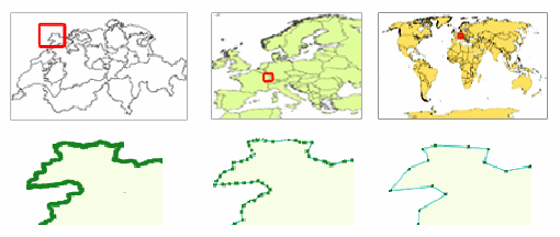
Is the geometry feature suitable for the selected scale? The suitability of the geometry feature is dependent on the scale of the map. For example, the geometry of a province depicted on a map in scale 1:200 000 cannot be so generalized as it is in world map of Fig. 3 because important information about the exact shape of the province will be omitted. On the other hand, using a too detailed geometry for a province as in Fig.1 on a world map does not make sense, since the scale in too small.
Compare the feature you have selected with the 3 cases here and see if it is suitable to be used for your thematic map according to the scale you have set. Note: If the geometry is too detailed or too generalized than the scale requires, new geometry data should be found and loaded to the wizard, in order a correct thematic map to be created.
|