| Name | Last modified | Size | Description | |
|---|---|---|---|---|
| Parent Directory | - | |||
| @eaDir/ | 2022-07-07 13:34 | - | ||
| Lake District Access/ | 2019-12-08 14:01 | - | ||
| Map Sales/ | 2019-12-08 13:55 | - | ||
| Printer/ | 2019-12-08 13:55 | - | ||
| u-blox token.txt | 2019-10-12 20:12 | 23 | ||
| website.rtf | 2008-10-26 16:35 | 235 | ||
| OrienteeringMapList...> | 2020-01-17 10:52 | 247 | ||
| ReopenSelectionManag..> | 2020-06-13 10:24 | 269 | ||
| Office Location Lat ..> | 2019-01-26 09:25 | 410 | ||
| How To Rotate to Mat..> | 2014-08-28 07:46 | 711 | ||
| updated prices.txt | 2004-10-18 11:56 | 2.4K | ||
| Untitled 1.csv | 2014-01-02 22:40 | 2.9K | ||
| gsp notes.txt | 2009-01-04 22:10 | 3.0K | ||
| gridreferencefinder.PNG | 2020-05-02 09:37 | 4.6K | ||
| BOF licence.txt | 2010-03-28 23:25 | 6.4K | ||
| Mapping Officer Role..> | 2006-12-03 16:12 | 7.4K | ||
| ocad pricing for Tea..> | 2018-09-01 13:45 | 8.1K | ||
| O-zone_poster.ppp | 2007-07-15 23:23 | 9.0K | ||
| SROC Planning Notes.txt | 2006-11-22 23:40 | 9.1K | ||
| Scan2Cad Instruction..> | 2004-04-29 00:53 | 9.5K | ||
| PacingScale2014.xls | 2013-12-26 10:08 | 9.7K | ||
| 5yr-plan-Sept-08.xls | 2008-10-12 22:32 | 10K | ||
| GPS HowTo.ppp | 2008-12-26 22:02 | 11K | ||
| ArticleAboutGeorefer..> | 2018-09-06 20:43 | 12K | ||
| AREAS.sql | 2020-11-21 09:50 | 14K | ||
| Untitled 1.ods | 2016-07-31 09:18 | 14K | ||
| PrintingCosts.xls | 2005-10-11 21:53 | 15K | ||
| Georeferenced Aerial..> | 2018-08-19 23:38 | 15K | ||
| Owners.xls | 2002-01-14 21:34 | 16K | ||
| SROC Areas.ods | 2020-04-25 10:32 | 16K | ||
| Expenses.xls | 2005-10-16 23:31 | 16K | ||
| OCAD LICENSE.lwp | 2007-05-04 22:35 | 16K | ||
| club membership list..> | 2013-03-25 20:47 | 17K | ||
| OPAPZ Prices.xls | 2004-01-21 22:15 | 18K | ||
| SROC Areas.pdf | 2019-10-06 08:22 | 22K | ||
| u-center assist now ..> | 2019-01-26 08:53 | 24K | ||
| Mapping Officer Role..> | 2006-12-03 15:57 | 25K | ||
| Mapping Officer Role..> | 2008-10-09 22:58 | 25K | ||
| AGREEMENT FOR LOAN O..> | 2008-10-17 22:45 | 26K | ||
| GPS and OCAD9.pdf | 2008-12-26 15:34 | 27K | ||
| South Ribble Oriente..> | 2005-06-14 22:44 | 27K | ||
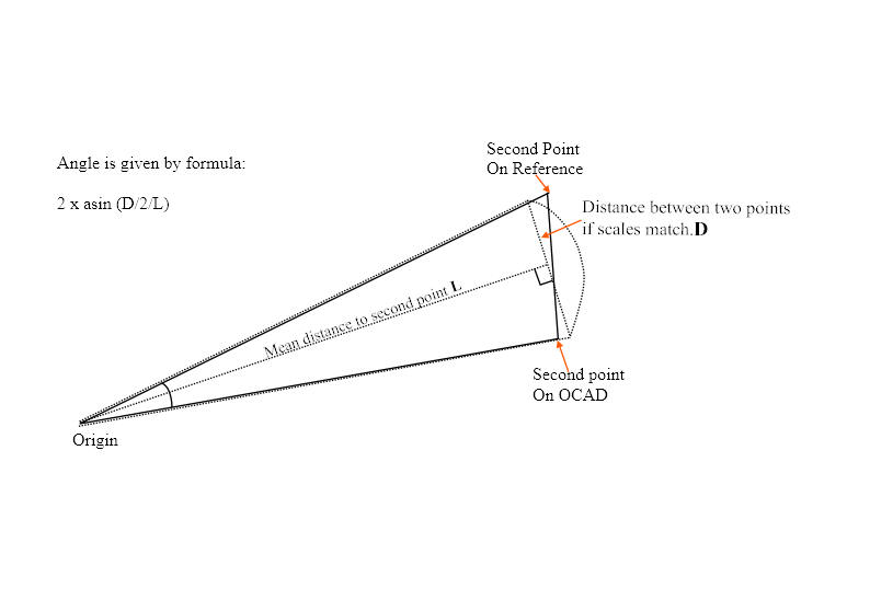
| AngleFormula.dpp | 2020-05-02 11:00 | 29K | ||
| OCAD 11 LICENSE ACTI..> | 2014-02-13 21:29 | 35K | ||
| White.ocd | 2009-08-18 00:13 | 35K | ||
| SROC Website.pdf | 2008-10-26 15:23 | 40K | ||
| PacingScale.xls | 2018-07-28 10:34 | 43K | ||
| mapregistration_mr1.doc | 2003-01-01 17:56 | 43K | ||
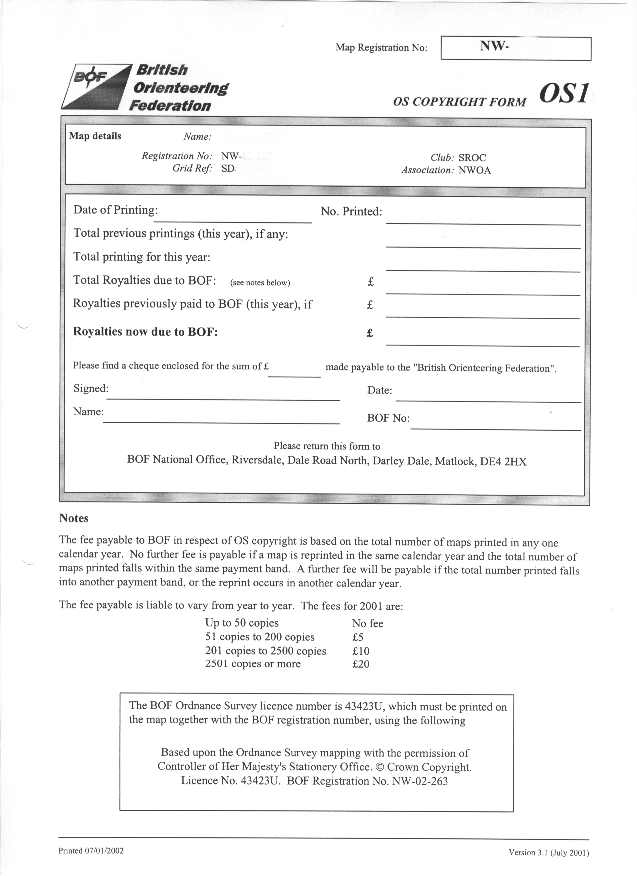
| BOF Form MR1.doc | 2001-12-29 11:59 | 44K | ||
| Backup Copy of BOF F..> | 2001-12-29 11:59 | 44K | ||
| CreateAerialPhotoFro..> | 2018-09-05 20:04 | 50K | ||
| CreateAerialPhotoFro..> | 2019-02-04 21:18 | 54K | ||
| CreateAerialPhotoFro..> | 2018-09-04 10:11 | 57K | ||
| Using u-blox neo-m8n..> | 2019-01-26 09:18 | 59K | ||
| ocaderror.PNG | 2019-02-04 08:09 | 65K | ||
| Map01.doc | 2001-07-25 22:33 | 66K | ||
| Red.ocd | 2009-08-18 00:21 | 71K | ||
| mr1.rtf | 2006-08-11 21:51 | 86K | ||
| ocaderror2.PNG | 2019-02-04 08:12 | 87K | ||
| SSE Southern Gas Di..> | 2020-06-11 19:58 | 90K | ||
| SSE Southern Electri..> | 2020-06-11 19:58 | 91K | ||
| Shelf Labels.PPP | 2002-01-11 12:52 | 91K | ||
| QMS colours.ocd | 2005-02-02 08:43 | 94K | ||
| 2018 Proof of Insura..> | 2018-10-20 07:53 | 96K | ||
| regsguia1p0.pdf | 2007-09-18 23:47 | 106K | ||
| Area Details.doc | 2020-11-29 23:03 | 110K | ||
| Georeferenced Aerial..> | 2018-09-02 13:27 | 113K | ||
| Receipt for Kadampa ..> | 2019-03-07 08:04 | 119K | ||
| Georeferenced Aerial..> | 2018-09-02 13:27 | 124K | ||
| Dave's Area Details.doc | 2008-09-30 21:07 | 125K | ||
| UtilityAidLOA2020.pdf | 2020-06-22 09:25 | 137K | ||
| How To Georeference ..> | 2020-05-02 11:48 | 144K | ||
| CreateAerialPhotoFro..> | 2018-09-05 20:04 | 148K | ||
| CreateAerialPhotoFro..> | 2019-02-04 21:15 | 153K | ||
| CreateAerialPhotoFro..> | 2018-09-04 10:12 | 156K | ||
| PacingScale.ocd | 2018-07-25 15:27 | 170K | ||
| riskassessmentforeav..> | 2007-09-20 22:28 | 175K | ||
| riskassessment.rtf | 2007-09-18 22:47 | 175K | ||
| Thumbs.db | 2022-05-22 15:30 | 176K | ||
| ISOM-2017-correction..> | 2019-03-20 22:38 | 251K | ||
| march09 address list..> | 2009-04-16 22:53 | 253K | ||
| BOF Symbol Set for S..> | 2019-12-13 07:54 | 261K | ||
| CreateAerialPhotoFro..> | 2020-07-04 14:39 | 262K | ||
| Ordnance Survey Cont..> | 2009-05-05 21:30 | 263K | ||
| CreateAerialPhotoFro..> | 2020-07-04 15:28 | 264K | ||
| CreateAerialPhotoFro..> | 2020-06-13 10:38 | 284K | ||
| BOF O_Map 4000 O18 v..> | 2019-12-12 18:16 | 288K | ||
| PacingScale45pacesPe..> | 2019-03-04 08:25 | 291K | ||
| BOF O_Map 10000 O18 ..> | 2020-01-23 09:54 | 327K | ||
| BOF O_Map 15000 O18 ..> | 2020-01-23 09:55 | 331K | ||
| FAQ's 2018.pdf | 2018-10-20 07:51 | 364K | ||
| SASPlanet instructio..> | 2020-06-09 07:47 | 372K | ||
| BOF Symbol Set for S..> | 2019-12-13 07:55 | 384K | ||
| AFA_application_form..> | 2004-04-26 23:40 | 386K | ||
| AFA_app_pack.pdf | 2004-04-26 23:40 | 428K | ||
| KYS-ISOM-2017.pdf | 2020-04-27 08:25 | 489K | ||
| SASDOWNLOAD.PNG | 2020-06-13 10:21 | 495K | ||
| CreateAerialPhotoFro..> | 2020-06-13 10:43 | 496K | ||
| CreateAerialPhotoFro..> | 2020-06-13 10:38 | 496K | ||
| CreateAerialPhotoFro..> | 2020-07-04 15:28 | 506K | ||
| MR12007.doc | 2009-02-14 23:35 | 518K | ||
| BOFOS1.BMP | 2004-01-25 11:25 | 549K | ||
| IOF Printing & Colou..> | 2022-07-07 13:34 | 944K | ||
| Mapping Conference 2..> | 2007-06-19 22:54 | 1.1M | ||
| mappers_georeferenci..> | 2017-12-22 07:31 | 1.2M | ||
| AngleFormula.png | 2020-05-02 11:00 | 1.3M | ||
| ISOM2017_20May2017.pdf | 2017-09-19 07:58 | 2.5M | ||
| Creating Field base ..> | 2019-01-24 20:29 | 3.8M | ||
| isom2017.pdf | 2017-12-17 22:25 | 4.3M | ||
| LancasterAreas.ZIP | 2007-01-09 22:18 | 4.6M | ||
| ISOM 2017-2 (Adjuste..> | 2020-05-15 07:39 | 8.0M | ||